
California area earthquake probability:
More than 99% probability in the next 30 years for one or more magnitude 6.7 or greater quake capable of causing extensive damage and loss of life.
Prepare Now
- Secure bookcases, televisions, and objects that hang on walls. Store heavy and breakable objects on low shelves.
- Practice Drop, Cover, Hold with family and coworkers.
- Create a family emergency communications plan that has an out-of-state contact.
- Plan where to meet if you get separated. Choose 2 locations:
- One close to home, and
- A central location that is manageable based on where your family works, goes to school, and plays.
- Be sure you have a home emergency kit with everything you need for at least 7 days.
- Learn more about building a survival kit
- Consider obtaining an earthquake insurance policy.
- Learn more about Earthquake Safety for Homeowners
- Consider a retrofit of your house to correct structural issues.
- For help and advice, see the Sonoma County’s Energy and Sustainability website.
- Now available, MyShake, app for your phone. Get notifications about nearby earthquakes and track earthquakes around the globe. Quickly understand what damage and shaking reports from USGS and community reporting. Your participation helps collect valuable data from the earthquake.
- More information: Staying safe where the earth shakes
Video: When the Earth Shakes
More information about earthquake preparedness from Ready.gov.
When the Shaking Starts 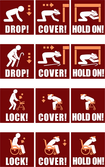
- Duck or Drop down on the floor:
- In a wheelchair? Lock the chair and bend over protecting your head and neck.
- Unable to get on to the floor? Try to protect yourself by bending over, bracing yourself, and covering with head and neck with your hands.
- Take cover under a sturdy desk, table or other furniture
- Hold on to it and be prepared to move with it.
Stay indoors until the shaking stops. If you’re outside, find a clear spot away from buildings, trees and power lines and drop to the ground. If you’re in a car, slow down and drive to a clear place.
After the Shaking Stops
Assume there will be aftershocks:
- Get to a safe place outdoors if you think the structure you’re in is in danger of collapsing.
- Check on neighbors, co-workers, and anyone who might need help.
- Provide first aid for anyone slightly injured and seek medical attention for anyone seriously injured.
Look around for possible hazards during aftershocks:
- Secure anything heavy that could fall and eliminate fire hazards.
- Go to SoCoEmergency for official updates and information.
- If you smell gas, or think it is leaking, shut it off.
- Remember: Only a professional should turn it back on.
More Information
Major Earthquake Fault Zones and Areas of Liquefaction
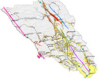
This Sonoma County Hazard Mitigation Map provides data on both earthquake faults and liquefaction zones.
Download map (PDF: 1 MB)
Earthquake Fault Zones
- The Healdsburg Fault (green) runs west of Highway 101 from central Santa Rosa to south of Healdsburg.
- The Maacama Fault (blue) runs from north of Mark West Spring to Cloverdale, also west of Highway 101.
- Rodgers Creek Fault (dark purple) runs from south of Highway 12 to central Santa Rosa, west of Highway 101.
- The San Andreas Fault (bright pink) intersects land in Sonoma County at Doran Beach and Bodega Bay as well as south of Fort Ross traveling north to the county line just east of the coastline.
Areas of Liquefaction
Many of the populace areas in the county have some degree of liquefaction hazard. Liquefaction describes the reduction of soil robustness and strength when an earthquake occurs. Buildings on susceptible soil may lose integrity due to liquefaction causing stress on foundations.
- The areas of Very High Susceptibility (red) to liquefaction include parts of Dry Creek Rd north of Healdsburg and smaller parts of Westside and Eastside Roads through to Guerneville and Forestville., east of Highway 101 from Cloverdale south to east of Healdsburg, areas near Jenner and Duncan Mills, off of Cazadero Road, and a small area near Sonoma.
- Areas of High Susceptibility (orange) to liquefaction include many areas east of Highway 116, as well as locations adjacent to the Very High Susceptibility (red) areas. Additionally, areas of High Susceptibility (orange) far west county locations such as Salmon Creek, some areas in Bodega Bay, off of Valley Ford Rd, Tomales Rd, a small portion of southeast Rohnert Park, a small portion of central west Petaluma, and north of Sebastopol.
- Moderate Susceptibility (yellow) to liquefaction is adjacent to areas of High Susceptibility (orange) as well as large portions of land either side of Highway 12, large portions of land on either side of Highway 101 throughout the county which includes much of Santa Rosa, Petaluma, Windsor, and Healdsburg. Sonoma south to the county line and areas south of Petaluma are also in the Moderate Susceptibility (yellow) zones.
Other Resources
Visit the United States Geographical Survey for more information about specific earthquake threats.
Participate in the next Great Shake Out Earthquake Drill